Drilling Targeting Deeper Mineralization
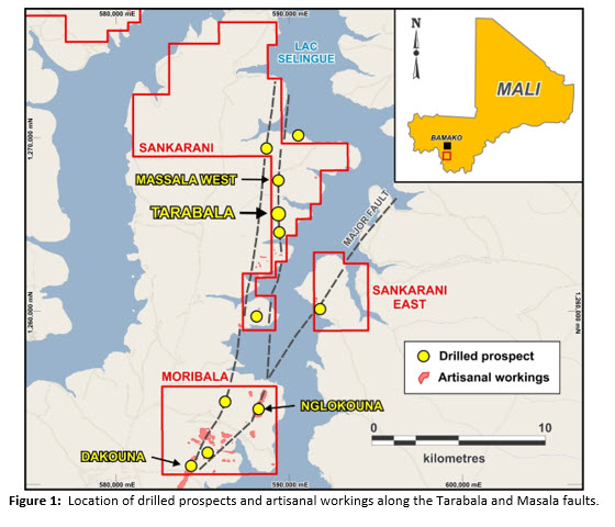
Toronto, Ontario, April 18, 2023 – Compass Gold Corp. (TSX-V: CVB) (Compass or the Company) is pleased to provide an update on the recently completed deep reverse circulation drilling at the Tarabala prospect, located on the Company’s Sikasso Property in Southern Mali (Figure 1)..
Highlights
- Drilling at the Tarabala prospect to test 450 m of a 1,000 m zone intercepted higher-grade mineralized areas within wide zones of low-grade mineralization
- Best interval: 13 m at 3.30 g/t Au (from 84 m), including 8 m @ 4.95 g/t Au (from 84 m)
- Highest-grade interval: 1 m @ 18.90 g/t Au (from 86 m)
- Widest interval of low-grade mineralization was 19 m at 0.84 g/t Au (from 170 m)
- Mineralization remains open at depth
- The Company is considering a metallurgical sample test program of high-grade, near-surface gold mineralization.
Compass CEO, Larry Phillips, said,“These are very positive results for Compass. Our objective has always been to identify an open pit gold deposit along the extensive regional trends that run through our properties. Whereas an open pit mine in Mali can be economic at 0.7 grams per tonne, we have discovered grades in this 450 m section of the Tarabala zone far exceeding that level. And even more exciting is that our drilling intercepted significant down-dip widths of gold mineralization at depths of just 125 m from surface. This includes some of the highest grade intercepts we have seen in this area, including 13 m at 3.30 grams per tonne, which bodes well for follow-up drilling.
Meanwhile, we are awaiting the results of the metallic screen fire assaying to determine if coarse-grained, nuggety gold is present in the samples. If it is, then it is likely that previously reported grades from drilling along the 14 km Tarabala trend were under-reported, which would indicate a huge potential for future resource estimations along several zones of that trend.”
Dr. Sandy Archibald, PGeo, Technical Director, added, “I am pleased with the promising results of our recent bedrock drilling at Tarabala, and eagerly await the metallic screen fire assay results to assess the presence of nuggety gold and the potential impact on reported grades.”
“Also, during my recent site visit, I was impressed to find that the number of artisanal workings at Tarabala has increased sharply since we last drilled there in August 2021. Field mapping now shows that artisanal workings have extended 1,000 m sporadically along the Tarabala Fault, and they have been excavated to depths up to 15 m. Similar increases in artisanal activity have also been observed within our Moribala permit area. There, these artisanal miners are typically extracting significant amounts of coarse-grained gold. As a result, we are assessing the potential for higher grade mineralization being present near surface along these trends and the economics of accessing that gold.”
Next Steps
Based on the recent drilling, the Company now believes that gold mineralization is open at depth and continues to the south of the main workings. Additional drilling is required along the full 800 m length of the target zone structure to enable the Company to perform an initial resource estimation. Preliminary studies suggest that this program will require 3,200 m of air core (AC) and reverse circulation (RC) drilling. A budget for this work will be prepared in order to determine what additional funding would be required. The Company will also develop a plan for deep trenching and pitting at Tarabala to determine the quantities of near-surface gold mineralization that can be recovered from the laterite. This would involve five 100-m trenches excavated to a depth of 5 m, and the collection and analysis of (2400) 1 m channel samples. A series of 5 m deep pits would be dug every 20 m between the trenches and the channels would be sampled for gold. Metallurgical testing would be performed to determine the gold recovery.
Tarabala Drilling Results Six RC drill holes (1,036 m) were drilled in early March at the Tarabala prospect to test the down-dip extension of mineralization previously identified by near-surface drilling there (See Compass press releases, June 15, 2020, January 20, 2021, and December 6, 2021).
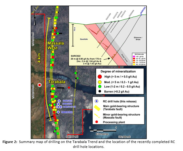
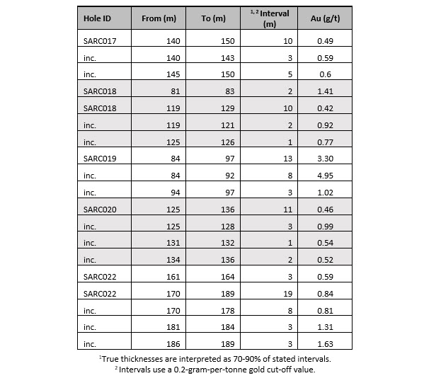
The holes were completed over the 450 m strike length of previously drill-tested shallow mineralization to test the grade and continuity at a depth of a 1,000-m panel of the best gold mineralization (Figure 2). Gold mineralization was present in all drill holes and was associated with narrow quartz veins associated with the highly sheared, graphite-rich, Tarabala fault. Wide zones of mineralization greater than 10 m were recorded in five holes: 19 m @ 0.84 g/t Au (from 170 m, SARC022), 13 m @ 3.30 g/t Au (from 84 m, SARC019), 11 m @ 0.46 g/t Au (from 125 m, SARC020), 10 m @ 0.49 g/t Au (from 140 m, SARC017), and 10 m @ 0.42 g/t Au (from 101 m, SARC018). Individual intervals within these mineralized intervals are narrower with higher gold grades (Table 1). For example, SARC019 had a mineralized interval of 8 m @ 4.95 g/t Au (from 84 m), and SARC004 contained an interval of 3 m @ 1.63 g/t Au (from 186 m). No significant mineralized intervals were encountered in SARC021.
SARC022 was the most southerly hole drilled and contained the widest mineralized zone, 19 m @ 0.84 g/t Au (from 170 m). This zone correlated well with previous shallower mineralization, i.e., SAAC080 (7 m @ 0.43 g/t Au, from 37 m; 3 m @ 5.13 g/t Au, from 47 m), SARC005 (13 m @ 0.79 g/t Au, from 84 m), and SADD004 (17 m @ 0.96 g/t Au, from 101 m), and clearly showed that the structure remains open at depth (Figure 2). Drilling occurred beneath an iron-rich crust (“cuirass”) where only small amounts of artisanal mining had been performed. However, where the cuirass has been naturally eroded 50 m to the south of SARC022, an extensive series of deep artisanal workings are currently being excavated, showing the workings are present over a distance of 1,000 m, which correlates well with Compass’ drilling results.
Tarabala Artisanal Workings Mapping and Nearby Processing Plant
The Compass field team has been mapping the abundance of artisanal workings on the ground and using drone technology on the Sankarani and Moribala permits. It is clear that the workings have grown substantially since they were last mapped from satellite images taken in 2019. Workings at Tarabala now occur over a strike length of 1 km and have been excavated to depths in excess of 15 m. The most extensive workings occur on the Moribala permit, where the Nglokouna workings follow the trace of the Tarabala Fault for 2.6 km, and the Dakouna workings for nearly 1 km on the Moribala Fault.
A site visit was also conducted to a nearby 200-tonne-per-day gold process plant, which is located 1 km northwest of the main area of artisanal gold working at Tarabala. This visit was to assess whether Compass could use similar equipment to process a bulk sample from Tarabala and Massala West to determine the gold recovery. These bulk samples would allow Compass to determine gold recoveries from the high-grade, near-surface portions of mineralization on the Tarabala Fault.
Technical Details
All six RC holes at the Tarabala prospect were drilled at dips of 55°, with azimuths of 270° (towards the west). Hole lengths varied from 115 to 200 m, for a total depth of 1,036 m. Drilling was performed by FTE Drilling, a Canadian company with a Malian subsidiary based in Bamako. All samples were prepared by Compass staff, and an appropriate number of standards, duplicates and blanks were submitted and analysed for gold using cyanide-leach (LeachWELL) analysis at ALS (Ouagadougou, Burkina Faso), and follow-up metallic screen fire assay at SGS (Bamako, Mali).
About Compass Gold Corp.
Compass, a public company having been incorporated into Ontario, is a Tier 2 issuer on the TSX- V. Through the 2017 acquisition of MGE and Malian subsidiaries, Compass holds gold exploration permits located in Mali that comprise the Sikasso Property. The exploration permits are located in three sites in southern Mali with a combined land holding of 867 sq. km. The Sikasso Property is located in the same region as several multi-million-ounce gold projects, including Morila, Syama, Kalana and Komana. The Company’s Mali-based technical team, led in the field by Dr. Madani Diallo and under the supervision of Dr. Sandy Archibald, P.Geo, is conducting the current exploration program. They are examining numerous anomalies first noted in Dr. Archibald’s August 2017 “National Instrument 43-101 Technical Report on the Sikasso Property, Southern Mali.”
Qualified Person
This news release has been reviewed and approved by EurGeol. Dr. Sandy Archibald, P.Geo, Compass’s Technical Director, the Qualified Person for the technical information in this news release under National Instrument 43-101 standards.
Forward‐Looking Information
This news release contains “forward‐looking information” within the meaning of applicable securities laws, including statements regarding the Company’s planned exploration work and management appointments. Readers are cautioned not to place undue reliance on forward‐looking information. Actual results and developments may differ materially from those contemplated by such information. The statements in this news release are made as of the date hereof. The Company undertakes no obligation to update forward‐looking information except as required by applicable law.
For further information please contact:
| Compass Gold Corporation | Compass Gold Corporation |
| Larry Phillips – Pres. & CEO | Greg Taylor – Dir. Investor Relations & Corporate Communications |
| lphillips@compassgoldcorp.com | gtaylor@compassgoldcorp.com |
| T: +1 416-596-0996 X 302 | T: +1 416-596-0996 X 301 |
Website: www.compassgoldcorp.com
NEITHER THE TSX VENTURE EXCHANGE NOR ITS REGULATION SERVICES PROVIDER (AS THAT TERM IS DEFINED IN THE POLICIES OF THE TSX VENTURE EXCHANGE) ACCEPTS RESPONSIBILITY FOR THE ADEQUACY OR ACCURACY OF THIS RELEASE.